
Open sand, designated routes, forest edges, multiple lakes, and several staging choices.
COOS BAY RIDING AREA
Spinreel
to Horsfall.
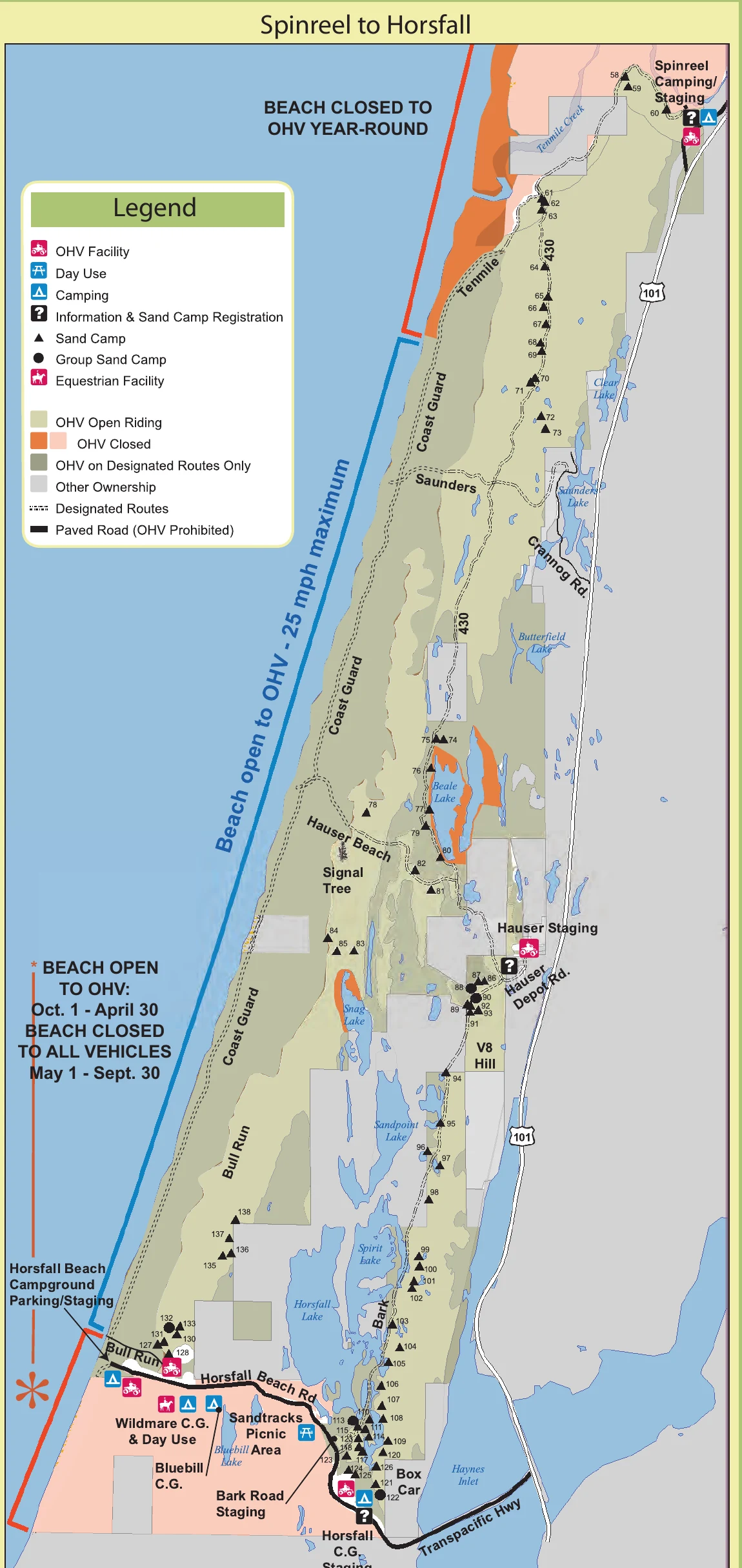
The southern zone has the most route decisions. This page brings the long riding map, major staging areas, named trail starts, camping, and GPS directions together.
Numerous entrances let a group choose its base around camping, services, or a preferred trail corridor.
The best starting point depends on which part of the long southern zone you intend to ride.
OFFICIAL RIDING-AREA MAP
Start with the section
you actually plan to ride.
The southern map is long because the riding network is long. Choose a staging area first, then study the named routes and boundaries around that entrance.
TRAIL STARTS & CONNECTIONS
Use the staging area that fits your route.
Tenmile & 430
Spinreel feeds the northern system. Tenmile and 430 provide major north-south connections toward the central riding area.
Coast Guard & Saunders
These named corridors help connect the middle of the zone. Watch the map closely where designated routes pass closed or restricted areas.
Hauser & Bark routes
Hauser Depot Road staging reaches central-south connections around Hauser Beach, Bark Road, Box Car, and nearby sand camps.
Bull Run & Horsfall
The southern staging network connects Bull Run, Horsfall Beach, camping areas, and the lower end of the open riding system.
OHV CAMPING ALONG THE ZONE
Match the campground to the trails you want.
Spinreel Campground
OHV-focused camping with access through Spinreel staging to Tenmile, Coast Guard North and South, and 430.
Open GPS ↗Horsfall-area campgrounds
Horsfall Beach, Horsfall, Bluebill, and Wild Mare provide different combinations of beach, camping, and riding access.
Open GPS ↗Riley Ranch County Park
A county OHV base south of the main Forest Service map area, useful for groups, trailers, and access toward the southern dunes.
Open GPS ↗TAKE IT OFFLINE
Keep the long route network in your pocket.
Install Avenza Maps and download the free current Siuslaw Map 3 before leaving service. Mark the staging area and planned regroup points.
- 1Install Avenza Maps on the phone you will carry.
- 2Download the free Siuslaw Map 3 while connected to Wi-Fi.
- 3Mark the correct staging area so the group returns to the right entrance.
BEFORE THE ENGINES START